SNAP Highlights: Summer 2020
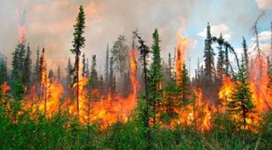
Summer has arrived in the Alaska Interior, which means long days, warm weather, bugs, and smoke. Rain returns in force to the southeast’s unique rainforest ecosystem this time of year, and its presence or absence dictates the cycle of wildfires common to south-central and the interior. High rivers and flooding can result from an overabundance of rain while drought can lead to high fire seasons, challenging growing conditions, and difficulty generating hydroelectric power.
SNAP maintains a number of web tools which can help Alaskans put their lived experience into the context of climate data both historically and in the future. The new series of SNAP Highlights features these tools with helpful explanation on a seasonal basis beginning with the summer of 2020.
SNAP web tools
In this season’s SNAP Highlights you’ll find details and guidance about the use of SNAP tools key to understanding fire and precipitation:
- The Alaska Wildfire Explorer enables users to investigate a map of fire activity historically, and currently as the fire season progresses alongside key variables that inform fire activity like vegetation type and lighting.
- The Daily Fire Tally tracks the current year’s total burned area across the state in real time alongside past high fire years.
- Use the Community Climate Charts tool to easily and simply understand what the latest climate models project for the future of precipitation across thousands of Northern communities.
Find out more in this season’s SNAP Highlights, as well as information about key datasets that have been produced or updated recently by the team.